The United Nations General Assembly has overwhelmingly backed an African-led push for world maps that more accurately reflect Africa’s true size, challenging a centuries-old projection that critics say has visually diminished the continent.
The “Correct the Map” resolution, led by Togo on behalf of the African Group and supported by the African Union, passed with 164 votes in favor, one against, and six abstentions. The United States was the only country to vote against the measure.
The resolution promotes greater use of equal-area world maps, including the Equal Earth projection, particularly in schools, international institutions, and public communications.
Why the Mercator Map Makes Africa Look Smaller
At the center of the debate is the Mercator projection, developed by Flemish cartographer Gerardus Mercator in 1569.
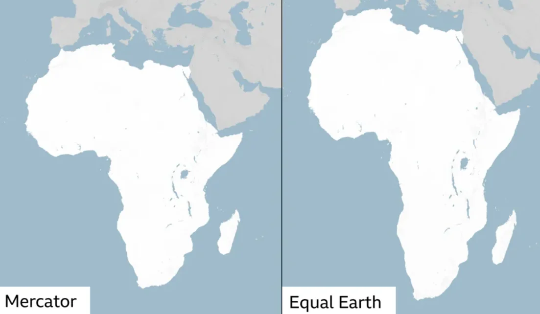
Designed primarily for navigation, the Mercator map preserves direction but dramatically distorts the relative size of landmasses, making territories farther from the Equator appear much larger.
One of the clearest examples is Africa and Greenland. On many Mercator maps, Greenland appears almost as large as Africa. In reality, Africa is roughly 14 times larger.
Supporters of the campaign argue that generations of exposure to distorted maps have influenced perceptions of Africa’s geographic scale, importance, and place in the world.
Equal Earth Map Offers a Different View of Africa
The resolution encourages the use of alternatives such as the Equal Earth projection, developed in 2018 to provide a more accurate representation of the relative sizes of continents and countries.
Togo’s Foreign Minister Robert Dussey, whose country spearheaded the UN initiative, has argued that maps influence how people understand the world and that correcting Africa’s representation is about more than geography.
The resolution describes the effort in terms of cognitive justice and memorial reparation, reflecting a wider African push to challenge inherited representations of the continent.
UN Resolution Does Not Ban Mercator Maps
Despite the significance of the vote, the resolution is not legally binding and does not prohibit countries from using the Mercator projection.
Mercator remains particularly useful for maritime and aerial navigation. Instead, the UN measure encourages governments, schools, international organizations, and technology companies to consider equal-area projections when accurately comparing geographic size matters.
The vote represents a major diplomatic victory for the African-led Correct the Map campaign and the African Union.
For its supporters, the message is straightforward: Africa has not become bigger. The world is being encouraged to see how big it has always been.